
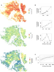
Temperature (T) and the relationship between vector carrying capacity (V) and human population density (N, number of human population in 250 m by 250 m) -i.e. V/N- in Delhi. © 2024 Romeo-Aznar et al.
This article, published in PLOS Climate Revue and cosigned by Olivier Telle, a health geographer at CNRS/Géographie-cités, shows that the role of climate factors in the transmission of mosquito-borne infections within urban landscapes must be considered in the context of the pronounced spatial heterogeneity of such environments. Socio-demographic and environmental variation challenge control efforts for emergent arboviruses transmitted via the urban mosquito Aedes aegypti. The authors address at high resolution, the spatial heterogeneity of dengue transmission risk in the megacity of Delhi, India, as a function of both temperature and the carrying-capacity of the human environment for the mosquito.
Abstract
Based on previous results predicting maximum mosquitoes per human for different socio-economic typologies, and on remote sensing temperature data, we produce a map of the reproductive number of dengue at a resolution of 250m by 250m. We focus on dengue risk hotspots during inter-epidemic periods, places where chains of transmission can persist for longer. We assess the resulting high-resolution risk map of dengue with reported cases for three consecutive boreal winters. We find that both temperature and vector carrying-capacity per human co-vary in space because of their respective dependence on population density. The synergistic action of these two factors results in larger variation of dengue’s reproductive number than when considered separately, with poor and dense locations experiencing the warmest conditions and becoming the most likely reservoirs off-season. The location of observed winter cases is accurately predicted for different risk threshold criteria.
Results underscore the inequity of risk across a complex urban landscape, whereby individuals in dense poor neighborhoods face the compounded effect of higher temperatures and mosquito carrying capacity. Targeting chains of transmission in inter-epidemic periods at these locations should be a priority of control efforts. A better mapping is needed of the interplay between climate factors that are dominant determinants of the seasonality of vector-borne infections and the socio-economic conditions behind unequal exposure.
Romeo-Aznar V, Telle O, Santos-Vega M, Paul R, Pascual M (2024) Crowded and warmer: Unequal dengue risk at high spatial resolution across a megacity of India. PLOS Clim 3(3): e0000240. https://doi.org/10.1371/journal.pclm.0000240
Olivier Telle is a health geographer at CNRS. His research aims to better understand how the rise in infectious and zoonotic diseases is connected to the environmental, political, and socio-spatial dynamics of cities in South and Southeast Asia (Singapore, Delhi, Vientiane, and Bangkok).
Plos climate
PLOS Climate is an open-access journal that furthers understanding of climatic patterns, processes, impacts and solutions by publishing transparent, rigorous and open research from diverse perspectives. PLOS Climate provides a venue for all areas of climate research, with an emphasis on collaborative, interdisciplinary and multidisciplinary work that improves global and regional understanding of climate phenomena and informs critical strategies for combating climate change.